On the morning of July 4, I headed west from San Antonio with my 19-year old son. We drove along Interstate 10 toward Fort Stockton. This was a four hour drive from San Antonio. Once in Fort Stockton we’d turn northward, with Carlsbad, New Mexico as the goal for the day. Leaving Texas, even from somewhere in the middle, does take an entire day of driving.
Along the way we passed Kerrville, and here we encountered pounding rain. At that time we had no idea of the tragedy unfolding along the Guadalupe River between Hunt and Comfort. I’ve driven along that river countless times since 1989. Both my kids have camped near Ingram, which is between Hunt and Kerrville. There are numerous low water crossings there, and I have only seen the Guadalupe River as a quiet stream while along the road next to the river. Only later would we learn the scope of the flooding, and all the lost lives, including dozens of young girls from Camp Mystic. A couple of hours after we passed Kerrville, in Ozona, we switched drivers. Here I checked the news, and saw the unimaginable headlines: young campers missing, vacationers missing, residents missing. Massive flooding beyond the 100 year event. The news was almost too horrible to imagine. Since then I’ve learned that families in my neighborhood have been affected, have lost people.
We took a break in Fort Stockton for lunch, then headed up the slow road northward, somewhat subdued. Speed limits in New Mexico are different from those in Texas, so it took time to get to Carlsbad. We arrived at our hotel just past 4pm, checked in, and rested. When we went out for dinner, we thought we’d have many options. However, as it was July 4th, most places were closed. After a long wait at one of the few open restaurants, we ate our late dinner.
The next morning we were up early and drove the hour south to Guadalupe Peak National Park. We arrived 15 minutes before the park offices opened, and were first in line outside their doors. Two surly park employees sat behind the counter. I paid the entrance fee, but as the person helping me said nothing; I matched her, asking only about a park pass. I overheard the other employee advising someone to carry lots of water, mentioning multiple rescues as if it was an imposition. Meanwhile, the person who helped us said nothing. Either we looked like we knew what we were doing, or she didn’t care. Back at the car, we drove to the trailhead, grabbed our gear, and headed to the trailhead. Then again, we had prepared for the environment, brought lots of water, and had serious hiking experience. I guess we did know what we were doing.
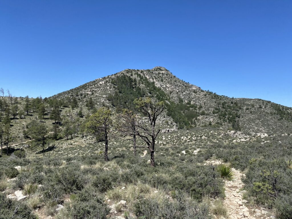
There are many trails in Guadalupe Peak National Park. Our goal today was the summit, at 8,751 feet above sea level, and about 3,000 in elevation gain. Supposedly everything’s bigger in Texas, though Colorado and California have those altitudes beat by at least 6,000 feet in elevation, and Colorado has dozens of peaks over 14,000 in elevation, easily beating Texas.
A sign inside the park office warned people that the first two miles were the hardest. They were off by around half a mile. We took our time going up those two and half miles, stopping at regular intervals for water breaks. Even after two miles the views were breathtaking. Along the trail, we grumbled as we headed upward, as it had been some years since our last mountain hikes.
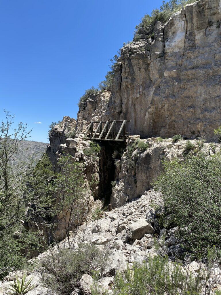
After those first two hard miles, the trail evened out slightly. The terrain changed, and we saw trees and meadows. With around a mile and half to go, there’s a side trail toward a wilderness camping area. We took that side trail, as I wanted to check out that site; years ago I’d thought about an overnight hike here, but went with Big Bend instead. At the camping site we took a short break, then returned to the main trail. We thought we saw the peak from that vantage point, but it was still a thousand feet of gain from there. The trail then crossed a bridge, which seemed out of place on such a trail. This bridge spanned a section where a rockslide appeared to have broken the path. Shortly after this, the last half mile turned into a scramble uphill. This was one of two places where signs warned people to dismount and lead pack animals, which confounded me. How could any mules or horses handle the trail, I thought? Still, it happens.
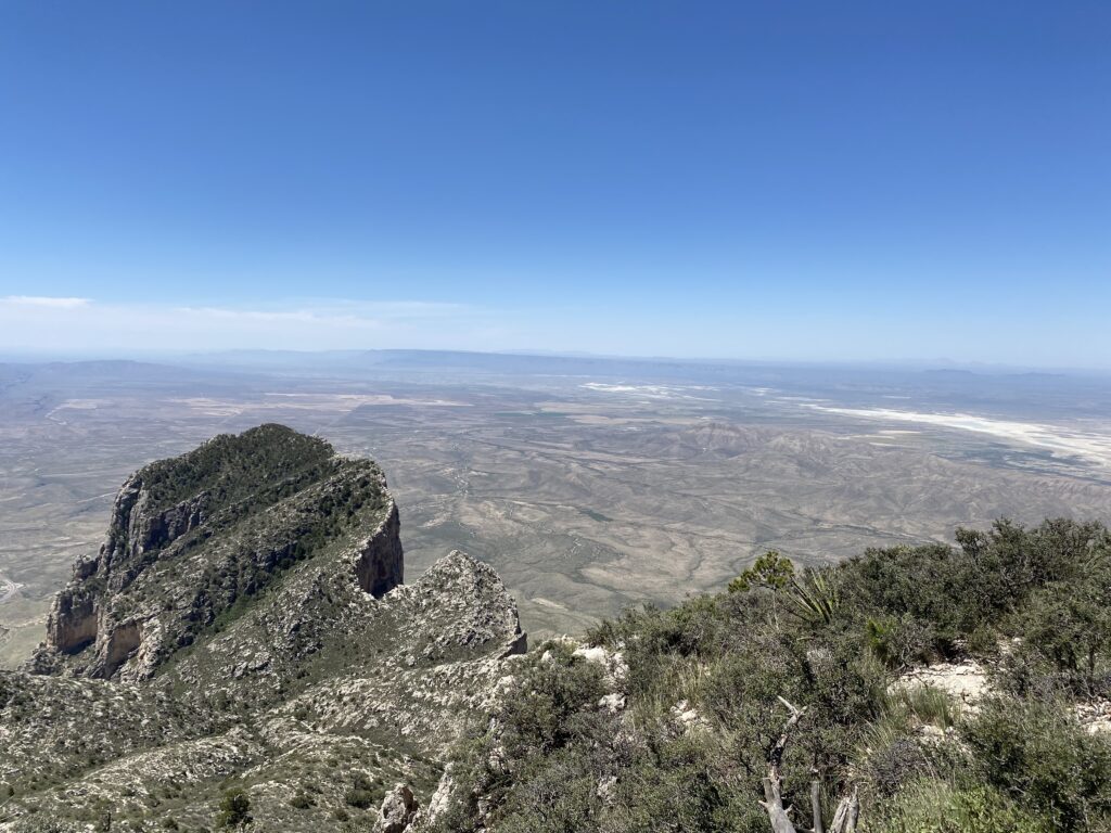
At last we reached the peak, exhausted and hungry. Since it was the peak of Summer (no pun intended), it was fairly warm throughout the hike. The peak was noticeably cooler, though still exposed. We found a shaded area, where we ate some food and rested. There we saw a snake a few feet from where we sat, though we didn’t think it was venomous. It was exactly noon when we reached the top, and several people sat on rocks around the peak. Some of them took selfies and other photos, posing as if they were models. Thankfully there was no wind or clouds. The Guadalupe Peak area is known for strong winds in the Fall through Winter, and sometimes there’s flooding.
It had taken us three hours to reach the top, though this included many breaks for water. Going down took only two hours, even with occasional breaks. The park notice stated that a round trip usually takes 6-8 hours. Our total moving time was just over three hours, but then we were consistently taking breaks to drink water, given the heat, dry air, and elevation.
Guadalupe Peak is a popular hike. We met several hikers on our the way up. Maybe they had camped and started earlier than us. We also saw a couple of hikers heading up as we descended. Some hikers didn’t seem prepared for the terrain or weather; people in sandals, not carrying any water, seemed out of place. When we’d checked in at the office, I overheard one of the rangers saying that on average they had to rescue people three times a week. Although few people have died on this mountain, it’s a fairly easy trail. I’d rate it around 4 out 10, but then I’ve hiked in many places. We met some people who probably thought it closer to 8 out 10, but also saw young children on the trail. Weather is critical, so if you plan to hike this trail, be aware of winds and temperatures.
I’ve now hiked both Big Bend National Park and Guadalupe Peak National Park, both in far West Texas. This is desert country, although there’s elevation and mountains mixed into the landscape. I do need to see more of East Texas, but from what I know of that area there are swamps, alligators, and snakes there, so maybe I’ll pass. I’d like to hike some of the other trails in Guadalupe Peak National Park, but some of them require camping and better planning, or better timing. And, it’s a hell of a long drive to get there from here. If you’re ever in that area, it’s well worth a visit. Planning’s important, though. Don’t get caught without water. Wear proper shoes. Start early. Pay attention to wind and temperature. Check the weather forecast.