Lost worlds and ports of call

Category: hiking (Page 2 of 2)

The Steep Approach to Springer

On April 14, 2024 I took my real first steps on the Appalachian Trail (aka the AT).

Well, ok, I’d walked a few yards on the AT in the past—in the same location—once in ignorance and once deliberately. This was at Harper’s Ferry, in 1998 and 2023, the former before I knew anything about the AT, and the latter just to tell myself that yes, I had trod on that path. I never expected to be on that trail again for many years, if ever, due to work commitments.

I learned about the Appalachian Trail around 2017 or 2018, and then almost by accident. My son was in Boy Scouts, and I was planning some hiking trips with a goal to hike some trails in Philmont, one of the high adventure locations in New Mexico. I read a great deal about hiking and proper gear, and in that reading I came across a blog by an Australian who’d completed the Triple Crown, a feat of long-distance hiking in the USA that included the Continental Divide, the Pacific Crest Trail, and the Appalachian Trail. At almost the same time, my company had a couple of off-site meetings north of Atlanta. Right after the second meeting, I learned that the southern terminus of the AT was around an hour’s drive from that location, and vowed if I ever had the opportunity to return that I would at least visit that location.

In the meantime I watched lots of videos from people who hiked the AT, read books about the AT, and the trail at that point became almost a personal holy grail. I didn’t think I’d ever complete a “thru-hike,” as that required five to six months, but I wanted to at least hike part of the trail. Also, in the meantime I hiked a lot (over 500 miles in five years), but always with a group. My son and I hiked part of the Colorado Trail (only 29 miles). We hiked around Lake Georgetown (north of Austin), several locations in Big Bend (the state park and national park), a few places in Norway, Utah, Nevada, and even a long trek in Philmont. Yet, never had I hiked alone.

That all changed in April, 2024. When my company announced the 2024 off-site would take place back in Georgia, I made my plans. I would take four days to hike 40 miles, from Amicalola Falls to Neel Gap. Then, a shuttle company would take me back to Amicalola State Park, from which I would drive the hour to the off-site meeting. A perfect plan. Or so I thought.

I arrived in Atlanta two days prior to the hike, drove through heavy traffic from their airport to REI—an outfitter store—where I picked up a gas canister and some water purification tablets. The next day I bought some food the at a couple of grocery stores (Aldi and Lidl, which don’t exist in central Texas). Then, the day before the hike, I drove to Amicalola State Park. This is the location where hikers who are planning to go the whole way pick up tags marking them as thru-hikers. It’s also the start of the “approach trail” to the souther terminus, which is Springer Mountain, over eight miles away. I sorted out a long-term parking pass with the staff, walked up the trail to the top of the falls, and checked into the Lodge, and hotel up the hill from the park. The weather looked great, according to my map the trail didn’t seem difficult, and I looked forward to the next few days.

Little did I know that things are different on the AT, especially when carrying 30 plus pounds of gear, food, and water on your back. Little did I know how much the trail goes up and down, vs. up to stay there before a final descent.

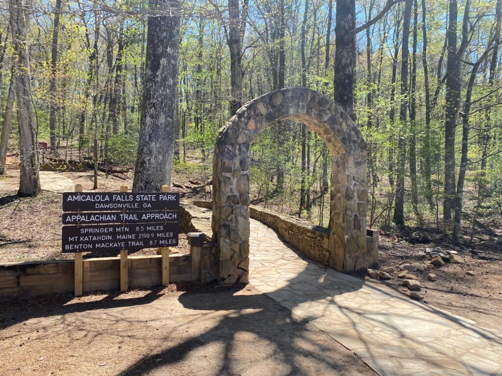
The “approach trail” stretches for over eight miles, and much of it involves going uphill. I learned that much of the AT itself involves a lot of uphill, and a lot of downhill. I’m not sure which part is worse. I started out early in the morning, after a quick breakfast at the lodge. Here I grabbed some lightweight jam packets to use with my peanut butter packets and pita break for lunches. Then I drove down the steep hills to the visitor’s lodge, parked my car, and headed to the visitor center buildings.

I was delayed slightly while i debated whether or not to attend a session from one of the park rangers. Since they were busy with thru-hikers, I gave up after half an hour of waiting and started up the trail. I didn’t need to register, since I was only hiking 40 miles. I also had the 10 essentials, as well as filters, water purifiers, and a bear canister. No “noob” on the trail here…. The approach trail usually goes along the river toward the falls, but part of that trail was closed, so I took an alternate route. I’d climbed many of the stairs near the falls the prior day, so it didn’t bother me to skip that part.

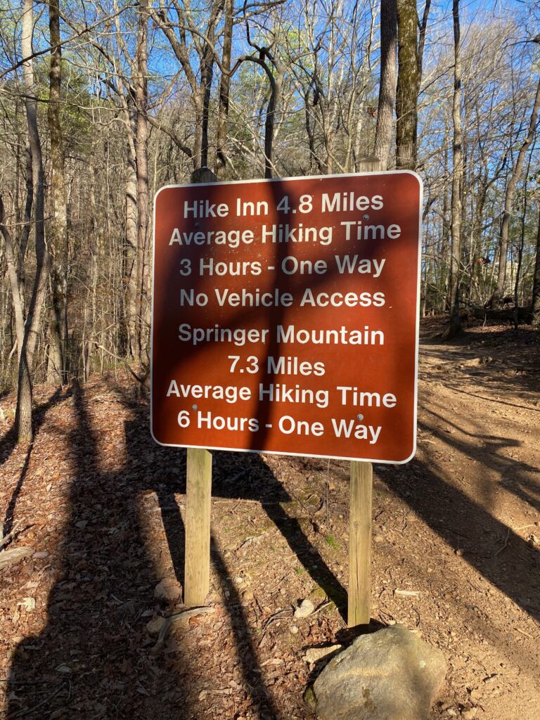
The sign indicating the trail to Springer warns hikers that it’s a long trek, an average of six hours. I did it in far less, but the finally climb up Springer almost did me in. At one point I paused at a rock a few hundred meters near the top, next to another hiker. For a moment, I felt like I blacked out, as I heard nothing of his comments. Meanwhile, a young woman with an accent that sounded German passed me, with perhaps a scornful glance. To her this hike was nothing, but I had at least thirty years on her, and I hate cycling/walking/running uphill anyway. Scorn mean nothing at that point. Still, after a while resting on a rock, I gathered myself and walked up the remaining short distance to the official start of the AT.

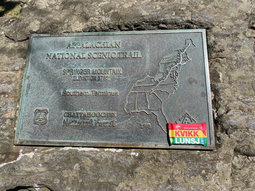
At the top of Springer I encountered some other people, a mix of thru-hikers, day-hikers, and section-hikers like myself. People took photos, marveled at the location; to some it was the start of a major adventure. I ate snacks, including maybe the first Kwik-Lunsj on the AT—a Norwegian chocolate that I’d brought with me for this occasion. Then, it was a matter of a short hike down to the parking lot, and continuing onward along the actual Appalachian Trail

To be continued…

Hiking Pikes Peak

Pikes Peak is a mountain in Colorado, near the town of Colorado Springs. It’s a Fourteener, meaning the peak is above 14,000 feet, or 4,267 meters. This is a curious American affectation, perhaps a 14er sounds more impressive than a 4.267er. There are 96 peaks known as 14er in the US, 53 of them in Colorado. The state with the next biggest number is Alaska, with 29. Some of the 14ers in Colorado have high difficulty ratings. Not so Pikes Peak. In fact, you can drive to the top in the comfort of your car, or take a cog railway from Manitou Springs, just outside Colorado Springs.

If you hike, there are two routes: Barr Trail and Crags Trail. These take slightly longer than a car ride. Barr approaches from the town of Manitou Springs, Crags from the other side, requiring drive to the trailhead from Colorado Springs where we’d rented a house for a few days.

In May 2022, I hiked up Crags Trail to Pikes Peak with three friends. It was one of the toughest hikes in my life so far. Each time I push myself to a new hiking challenge, I learn things about myself—some good, some bad. Still, each other new challenge brings newer unknowns, and while you can prepare somewhat in theory, the actual practice of the hike is far, far different from what you read or hear from others.

Our hike took place in May, only a few days before the Crags campground opened to the public. This meant parking about a mile before the actual trailhead, walking around the barrier, and hiking up the dirt road. We left our rented house at 4:15am, arrived at the parking lot at 5am and started the hike 15 minutes later, before the break of dawn. At this point, we’re already above 9,000 feet, so the ascent means we’re only gaining just over 5,000 feet. Hiking Barr Trail means starting at around 6,500 feet, so a much bigger elevation gain. Still, it’s easy to forget you still have eight or so miles to walk from the car to the peak. You think at the start that you can cover three miles in an hour. You are quickly proven wrong.

The first part until the tree-line is relatively easy. You follow a trail that winds through forest and continually climbs, but at a manageable pace. Once we reached the tree-line, which is around 11,000 to 12,000 feet, we started to feel the wind. There were two short windbreaks around the area known as Devil’s Playground, so named for how the lighting jumps from rock to rock in that area when there are thunderstorms. Luckily, for us, the skies were clear.

Once we left those windbreaks, we were exposed to the elements, or rather the wind, as the skies were clear. It was cold, but not uncomfortably so. At this point, we’re hiking near the road that leads to the peak, although we’re on thinly worn trails, not along the road itself. There were some patches of snow that we were forced to navigate. At times we were knee deep in soft snow, but these were fairly short patches. The last mile or so took over an hour. The “trail” here ascended a boulder field, and consisted mostly of stepping from rock to rock, following the guidelines of tiny rock cairns placed by previous hikers. At one point I caught my foot in between two rocks and went down hard. Fortunately this didn’t result in any injury, aside from some minor abrasions and wounded pride.

Once we reached the summit, we sought a long break in the visitor center. This place has all the amenities tourists might expect: a restaurant, bathrooms, museum, gift shop, and more. We lingered here perhaps longer than planned. We tried the unique donuts, browsed the gift shop. I felt gassed, out of breath, and wondered if the fatigue I felt was just fatigue, or the hint of altitude sickness. Reaching 14,115 feet above sea level is no mean feat, especially if you’ve walked up each step (well, not from zero to the top, but still). We had no transportation reserved back down to the car, so after a long break (probably too long), we strapped on our gear once more, and headed back down to the Crags trailhead. I’m sure the people who drove up or took the railway were amused by our attire and backpacks, and the hiking poles we all carried, not to mention the glazed look in our eyes. Downhill should be easier, right?

By the time we exited the boulder field, the wind had picked up significantly. It was now early afternoon. Had this been summer, we would have faced the danger of storms and summer monsoon weather. Still, the winds appeared to reach speeds of 30-50 miles per hour, and we struggled all the way until the tree-line. We sought occasional shelter behind any rock big enough. I’m generally a fast hiker, but unforeseen circumstances (a busted hiking boot among the party), kept the pace slow.

Finally. Tree-line meant silence, a break from the constant buffeting of the wind. The wind above the trees never stopped, hitting us from the side, rear, and sometimes the front. Once sheltered by trees, there remained the sound of wind through the trees, but much calmer. Here we no longer felt the physical strain of the wind. Along the way, both up and down, we’d paused many times. We now faced the prospect of arriving back at the car after dark, much as we’d left the car while it still was dark.

It’s a curious feature of hiking mountains. Going uphill you’re focused on what’s immediately in front of you. You don’t see the big picture, unless you pause and look around. Going downhill the trail seemed to go on forever; you saw far more of it, and thus it seemed to take longer down the trail. In the end, we did arrive after dark, ordered pizza on the drive back the house, and considered the day a success. A hard-fought success, but a success nonetheless. I’d hike Pikes Peak again, but this time via Barr Trail, just to be different.

A trail too far

I may never set foot on the Appalachian Trail, but this 2,000 plus mile trail across the Eastern states has fascinated me since I heard about it a few years ago. Like millions of Americans I had no idea this trail or others like the PCT or CDT even existed; I knew of Appalachia, but thought this was only part of West Virginia, not that it rain from Georgia to Maine. The closest I’ve been to the AT is when I visited Harper’s Ferry in 1998. I didn’t know about the AT back then, and I have no idea where the trail went, or even if I touched part of it as I hiked along the river just outside the town.

After I herd about the AT, I knew the trail existed, somewhere. The exact location was one I never looked into, as it’s so far away from Texas. Even two and three years ago, while in Georgia for a company retreat, I didn’t know that an hour drive from where we were staying, was the southernmost end of the Appalachian Trail: Springer Mountain. The approach to Springer Mountain, from Amicalola Falls, might even be a day trip, even in February, if the weather cooperated.

When I read some hiker blogs in 2019 and learned how close I had been to Springer Mountain, I wondered if I’d ever get a chance to return to that area. Having started hiking and backpacking again in 2018, a new world was opening up to me, one where I slowly started to realize how far away Texas is from legendary hiking paths. By car, Springer Mountain is around 1,066 miles, and Mount Katahdin over 2,000 miles, nearly the same length as the entire AT. Even planning any section hike would require coordination with airline flights, shuttle services, and locating outfitters where I could buy at the very least gas canisters for a backpacking stove. Not to mention the cost. Both time and money are hard currencies required to get the trail.

Instead of planning any trips, I’ve started accumulating a small and random library of books about the AT. There’s the humorous entry of Bill Bryson’s A Walk in the Woods. Mostly funny, there are occasional illuminating moments. Bryson only hiked a third of the AT, but then the vast majority of thru-hikers tend to drop out anyway. For inspiration, Jennifer Pharr Davis’ Becoming Odyssa is invaluable. Here’s a young woman, just out of college, setting out across a vast stretch of America all on her own. For harsh reality, David Miller’s Awol on the Appalachian Trail reads like a depressing catalog of woes and pains, yet despite all his troubles, his still made it all the way. His book reads more like a warning than an inspiration. Miller also stayed mostly in shelters, huts, hostels, and motels, and I’d be tempted to tent, at least until the first experience of having to set up the tent in a rainstorm.

It’s a wonder to read about the blisters, lost toenails, sprained ankles, dehydration, nasty people, snakes on the trail, the threats of bear and moose encounters, the chances of tumbling down rocks and mountainsides, the heat, the cold, the bugs, the chance of drowning when fording rivers, the possibility of violence, the chance of getting lost, and more. And yet, ever year more and more people attempt to thru-hike or section hike this trail. On the flip side, the hikers who wear rose-colored glasses talk about trail-magic, friendly drivers, and how the trail becomes a part of you (inevitable, I suppose, if you spend half a year on it).

Would I hike it if I could? You bet. But I’m not the kind of person who throws himself into things without planning. I think it would take me at least two years to accumulate hiking knowledge before I’d make any such attempt. And I’d likely not attempt a thru-hike. For one, I cannot envision spending five to six months on the trail. At most, I’d split the hike into two, starting from the south each time. Even better might be to take four years, carving the trail into manageable sections.

Having read these books as well as a few online hiker diaries, I have nothing but the utmost respect for the people who attempt the AT. I’ll continue to read about the trail, but now look more for tips and ideas, not stories about daily miles and struggles. If I ever get a chance to visit Atlanta again, maybe I’ll bring a daypack and try to walk from Amicalola Falls to Springer Mountain. I suspect that if I ever set foot on the AT, I’ll want to keep walking.

Newer posts »

© 2026 Anders Monsen

Theme by Anders NorenUp ↑

css.php